- Mar 21, 2025
-
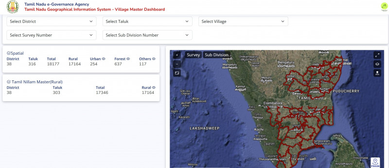
How to Use the TN GIS Village Master Dashboard to Check Road Access Before Buying Land
Thinking of Buying Land? Don’t Get Stuck With a Plot That Has No Road Access
Buying land is exciting — but here’s the harsh truth: many buyers end up with plots that have no legal road access, leading to endless legal trouble, no construction approvals, and poor resale value.
Before you sign any agreement, it is crucial to verify whether the land has a legal, government-recognised road connection. A landlocked plot — even if cheap — can become a lifelong headache.
✅ Good news: The TN GIS Village Master Dashboard is a free government tool that helps you verify road access quickly and accurately.
🚀 What Is the TN GIS Village Master Dashboard?
The Tamil Nadu GIS Village Master Dashboard is an official digital mapping platform developed by the Tamil Nadu Survey and Settlement Department.
Using this tool, you can:
- View survey maps and land boundaries
- Check land classification (residential, agricultural, etc.)
- Verify road access and connectivity
- Confirm legal paths connecting the plot to public roads
- Identify nearby government and village roads
👉 This tool is a must-use for anyone buying land in Tamil Nadu.
🛠️ Step-by-Step Guide: How to Check Road Access Using TN GIS
🔗 Step 1: Access the Dashboard
Visit the official portal:
👉 https://tngis.tn.gov.in/apps/village_dashboard/
✅ Step 2: Select District & Taluk
From the left panel:
- Choose your District (e.g., Tiruvannamalai)
- Select the relevant Taluk (Chengam, Kilpennathur, Polur, etc.)
✅ Step 3: Choose the Village
- Select the Village name from the dropdown
- The village map with survey boundaries will load automatically

✅ Step 4: Enter the Survey Number
- Enter the Survey Number of the land
- The dashboard will highlight the exact plot location on the map
🚗 Step 5: Check for Road Access (MOST IMPORTANT)
- Zoom in around the highlighted plot
- Look for clearly marked roads or pathways
- Public roads, village roads, highways, and cart tracks are shown in color

✅ Safe to proceed if:
- The plot directly touches a panchayat road, village road, or highway
❌ Avoid if:
- The plot is surrounded by private lands
- No government-recognized road touches the plot
👉 A plot without road access is legally risky.
📜 Step 6: Understand Land Classification
Click or hover over the plot to view:
- Land type (Nanjai, Punjai, agricultural, residential, etc.)
- Survey boundaries and neighboring lands
- Any government reservation or restrictions
✅ Prefer Nanjai / Punjai lands with clear road connectivity
❌ Avoid Poramboke, water bodies, or restricted lands
🧠 Why Road Access Is Non-Negotiable When Buying Land
🚫 Without Legal Road Access:
- No building plan approval
- No vehicle access
- Banks may refuse construction loans
- High chance of legal disputes
- Extremely poor resale value
✅ With Legal Road Access:
- Smooth registration and resale
- Easy access for water, EB, drainage
- Legal construction approvals
- Higher appreciation and long-term value
🔎 Quick Checklist Before Buying Any Plot
- Verify road access on TN GIS Village Dashboard
- Cross-check with Patta / Chitta / FMB
- Visit the site physically
- Ensure the road shown is public or panchayat road
- Consult a surveyor or VAO if anything is unclear
🌿 Prefer Verified Plots With Clear Road Access
Many buyers do all these checks to avoid legal issues — and then prefer DTCP-approved layouts where road access is already clear and documented.
If you’re looking for verified residential plots in Tiruvannamalai, you can explore projects like, Our talk to an expert to guide you:
- Siva Bhoomi Avenue – DTCP-approved plots near Girivalam Road
- Annamalai Avenue – Well-planned plots on the Bangalore Highway
- Kunal Garden – An upcoming project with planned road connectivity and legal clarity
- Vishal Garden - A project with best park and top class appreciation of your value
- Swarnabhoomi - A well established project in tiruvannamalai town
Such projects save buyers from future disputes and simplify registration, construction, and resale.
📝 Frequently Asked Questions (FAQs)
Is TN GIS Village Dashboard 100% accurate?
It is reliable for verification, but always confirm with physical inspection and local records.
Can road access be created later if the land is landlocked?
Yes, legally possible — but it involves long procedures, neighbor consent, and uncertainty.
Does DTCP approval guarantee road access?
Not always. Some layouts may be approved on paper. Always verify physical road presence.
✅ Final Thoughts: Don’t Let Your Dream Plot Become a Legal Nightmare
Buying land is a major financial decision. A few minutes spent on verification can save you years of legal trouble.
Use the TN GIS Village Master Dashboard to:
- 🔎 Verify survey boundaries
- 🚗 Confirm legal road access
- 📌 Understand land classification
Only then move forward with confidence.
👉 Access the official dashboard here:
https://tngis.tn.gov.in/apps/village_dashboard/
💡 Pro Tip: Always save screenshots of your online checks — they’re useful during registration or disputes.
Comments :
Currently, there are no comments in this post. Be the first person to comment on this post.